Feeds:
Posts
Comments

Posts Tagged ‘La Niña’

As we’re all aware, weather is never static. Weather conditions and patterns are always changing and are difficult to predict. One very recent example of this is the El Niño Southern Oscillation (ENSO). ENSO is a cycle of warming and cooling events in the equatorial Pacific Ocean and the atmosphere above it. These periodic events take place over roughly 2-7 year intervals. The resulting variability in oceanic and atmospheric temperatures has a range of effects on seasonal precipitation and temperature patterns across the world.

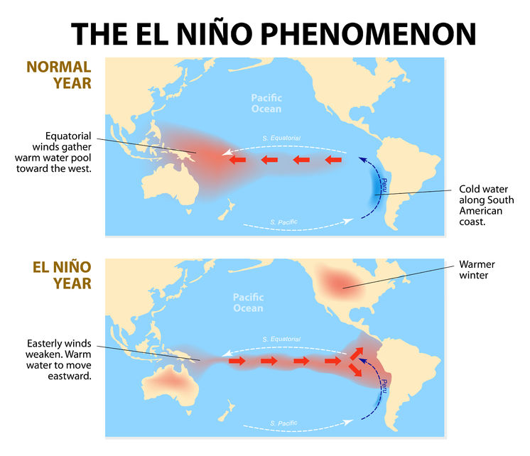
With ENSO, the cycle can shift form its neutral or normal state, to a warm phase – El Niño, or a cool phase – La Niña. We’ve been in one of the strongest El Niño phases on record for the last 2 years. During El Niño, the typical East-to-West winds weaken in the equatorial Pacific, which drives warm waters from the western Pacific to the eastern Pacific. This causes warm ocean surface temperatures and heavy precipitation in northern South America, and dry conditions in Australia and Indonesia.

El Nino

With the El Niño phase we’re currently in, there have been a lot of extreme weather phenomena. The monsoon rains weakened in India, resulting in food shortages, West Africa has been in a drought, Australia experienced record heat, Brazil experienced excessive rains, and the northern hemisphere winters were warmer than usual. For Texas specifically, there’s been increased precipitation events, making 2015 Texas’ wettest year on record.

Winter Comparison - NOAA Climate.govThis month though, scientists from the National Oceanic and Atmospheric Administration (NOAA) have issued an official “La Niña Watch.” They predict that El Niño will phase out in late spring or early summer, and will shift to La Niña for the fall and winter. So we can soon expect to see generally opposite conditions than we have been experiencing with El Niño.

La Niña results when cool ocean water intensifies the East-to-West winds across the equatorial Pacific Ocean. This causes warm oceanic temperatures in the western Pacific, which means heavy rainfall for Australia and Indonesia. Conversely, it causes cool oceanic temperatures in the eastern Pacific, resulting in dry conditions in South America.

Nina Winter - Weather Network
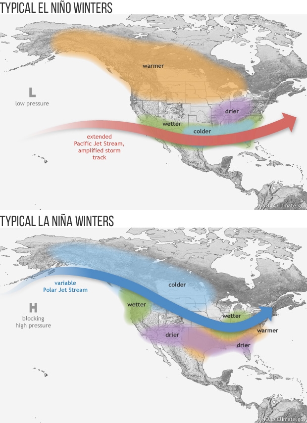
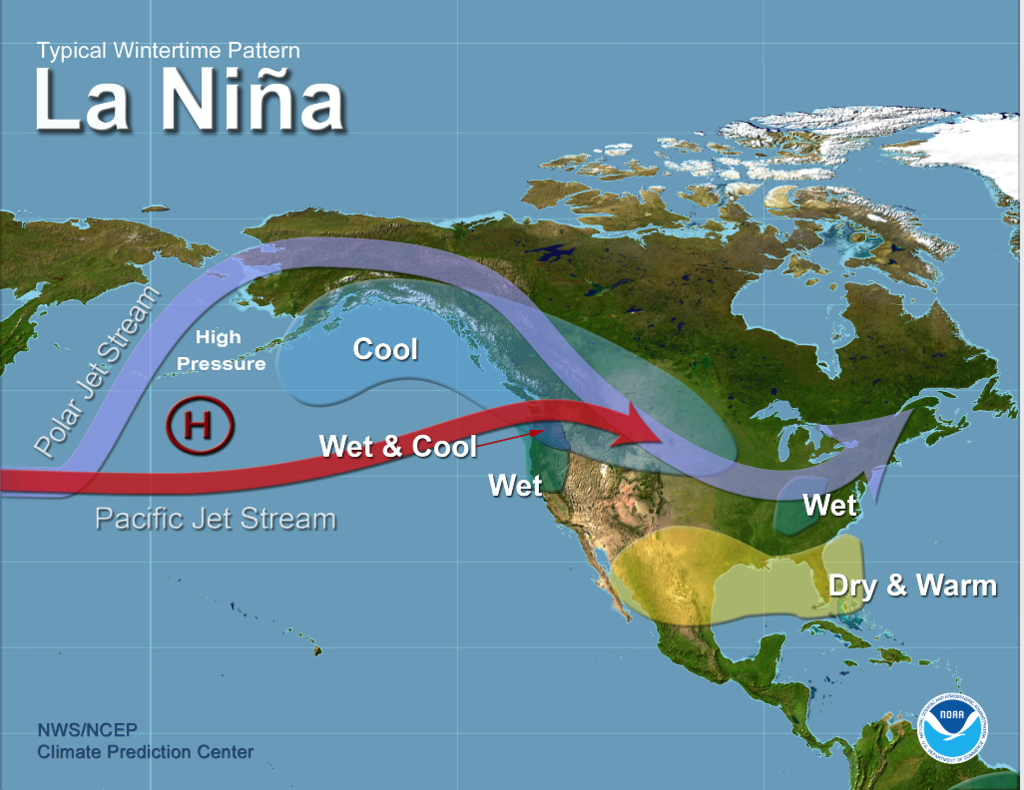
During La Niña winters, the U.S. experiences dry and warm conditions in the southern states, but wet and cool conditions in the Pacific Northwest and northern plains. We can expect there to be a lot of snow in the Pacific Northwest while there’s drought in California and Texas. In previous La Niña periods, the lack of rainfall negatively impacted Texas water supplies and crops. With La Niña, there’s also an increased chance of Atlantic hurricanes since the temperature and moisture flow associated with it creates ideal conditions for hurricane formation.

Even worse, research indicates that because of global climate change, El Niño and La Niña may hit twice as often as they did before. Climate models indicate that an extreme La Niña may hit every 13 years now instead of every 23 years, and an extreme El Niño may hit every 10 years now instead of every 20 years. Since a warmer atmosphere can hold more water and moisture, rainstorms can increase in intensity. For example, during a future El Niño, the West Coast may experience heavier downpours than usual. During a future La Niña, the added moisture in the air may make northeast snowstorms much stronger.

If the weather is always undergoing different cycles and is constantly changing, then why does an upcoming La Niña matter? Shifts in precipitation and temperature patterns alter crop production abilities, which will impact the prices of goods all over the world. Various commodities will be affected by the upcoming La Niña:
(more…)

Read Full Post »

Punxsutawney Phil is a groundhog resident of Punxsutawney, Pennsylvania. On February 2 (Groundhog Day) of each year, Phil emerges from his temporary home – if he sees his shadow and returns to his hole, he has predicted six more weeks of winter, if he does not see his shadow, he has predicted an early spring.  In Texas we have State Climatologist John Nielson-Gammon who emerged, saw his shadow and told Reuters, “It is possible that we could be looking at another of these multiyear droughts like we saw in the 1950s, and like the tree rings have shown that the state has experienced over the last several centuries.”

Some 95 percent of the state is listed as being in either “severe” or “exceptional” drought by the U.S. Department of Agriculture’s Drought Monitor, and Nielson-Gammon said the last 12 months have been the driest one-year period on record in the Lone Star State.

The state’s worst recorded drought lasted from 1950 through 1957 and prompted the creation of artificial lakes all across Texas to supply water to a state that at the time had a population of 15 million.  Those lakes are in place but after the worst one year drought on record and a population over 25 million, a multi year drought like the one we had in the 50s could be devastating for the state..

The long-term weather patterns, including La Nina currents in the oceans, mirror records from the early 1950s, Nielsen-Gammon said. The current drought, which he said began in earnest in 2005, could wind up being a 15-year stretch if patterns hold, he said.

“We’re very lucky that we had 2007 and 2010, which were years of plentiful rain,” he said. “2010 was the wettest year in record. Were it not for last year, we would be in much worse shape even than we are today.”

Conditions in Texas now are far from good. The drought has dried up many lakes built after the drought of the 1950s, and more than 23,000 separate wildfires fueled by dried brush and trees have destroyed 3.8 million acres and with that 2,800 homes, according to the Texas Forest Service.

Nielson-Gammon said Texas was now 10 to 20 inches of rainfall behind where it should be at the end of September and that rather than being the exception, severe drought could become the rule in Texas going forward, with wet years being more noteworthy.

“We’ve had five of the last seven years in drought, and it looks like it is going to be six out of eight,” he said.

The month is going out the same way it came in, with Texas firefighters on edge.   On September 4, a gust of wind blew a dead pine tree into power lines east of Austin, sparking the deadly Bastrop Complex Fire. That blaze killed two people, destroyed 1,600 homes, and is now the costliest fire in terms of lost property in Texas history.

The Forest Service this week called in two air tankers from Canada to fight wildfires that continue to burn around Texas, citing a shortage of enough planes to fight the state’s fires.

Read Full Post »

The worst Texas drought since the 1950s has a handful of cities facing a prospect they’ve never encountered before: running out of water.

Many lakes and reservoirs across the state are badly depleted after more than a month of 100-degree temperatures and less than 1 inch of rain. The worst-off communities are already trying to run pipes to distant water, drilling emergency wells bringing on systems that turn waste water into tap water and banning water use for virtually anything beyond drinking, bathing and keeping businesses working.

Worst-case scenarios have a few towns running out of water in a matter of months.  Although Texas cities have gone bone-dry before —Throckmorton in 2000 — the nearly 500 water systems statewide now under some mandatory restrictions appear unprecedented.

Prayer gatherings for rain have been held across the state, the most notable being called by Governor Rick Perry in July.  So far, these measures have not brought even the promise of rain for most of us.

In the town of Llano, near Austin, which went to Stage 5 water restrictions back around the 4th of July weekend, officials have made a contingency plan to roll trucks of bottled water into town if rain doesn’t start to replenish the water supply, and workers are drilling test wells into parched, rock-like soil. Water restrictions are in effect in unprecedented in places like Midland, where barely a half-inch of rain has fallen since October of 2010.

If La Nina conditions return this fall, which the Climate Prediction Center says is likely, Texas is unlikely to see any significant relief from this drought well into next year.

As I sit at my desk with the sun pouring through the window heating everything around me, knowing that just outside the front door it is still a soil scorching 103 degrees F, I think that it may be time to raise the specter of (duhn-duhn-duhhhhhhn) CLIMATE CHANGE.  Even if Governor Perry is traveling around the country telling everyone that scientists have cooked up the data on global warming for the cash, the numbers here in Texas seem to be refuting his claim and you can expect to see us blogging about it soon.

Read Full Post »

Texas is suffering from an historic drought and one question that looms large is – how much rain will we need to actually end the drought?  And the answer is –  A LOT!

The National Oceanic and Atmospheric Administration (NOAA) indicates 12 to 15+ inches of rain (shades of purple and dark blue) is necessary for most of Texas to end the drought, as shown in the graphic below.

Even those small parts of the state not needing those massive amounts of rainfall to end this drought will require six to twelve inches of rain to recover.  With the Climate Prediction Center now saying there is a 50/50 chance of a return to La Nina conditions this fall which almost always results in drier than normal conditions for Texas and most of the South, the potential for recovery any time soon is pretty slim.

It has taken months for the drought to get to the level it is at now and it will take months or even years to return to normal.  But all indications are that there is no major relief coming soon and if you haven’t already done so, consider taking measures to reduce your water and electricity use for the long haul.  For ideas on how consumers can do this, check out the Texas Is Hot website for tips on how to reduce your energy use, and TCEQ’s Take Care of Texas website for tips on conserving water.


Read Full Post »

The Climate Prediction Center says there is now a 50/50 chance of a return to La Nina conditions this fall.

La Nina is an expansive area of cooler-than-normal water in the Pacific Ocean. This cooling alters weather patterns across the U.S., and almost always results in drier than normal conditions for Texas and most of the South. And, when we’re drier than normal, we tend to be hotter than normal.

This is very bad news for Texas, as the 2010-11 La Nina is the reason for our existing drought and heat wave. Think the drought and summer heat is bad now (the Mid-West and East had a heat wave, what we are having is a heat tsunami), if we have a 2011-12 La Nina, this drought could reach epic proportions by next summer.

Read Full Post »